A complete list of publications related to MOPITT can be found on our Zotero library. If you are aware of any missing items please contact us to let us know.
Further lists of publications related to MOPITT can be found from the Canadian Space Agency (here) and on the NCAR website. The latter provides refereed articles (with and without abstracts), articles written by NCAR MOPITT team members (with and without abstracts), theses (with and without abstracts), and non-refereed articles (with and without abstracts).
In this section a few of the University of Toronto publications will be introduced.
The Impact of the 2023 Canadian Forest Fires on Air Qualityin Southern Ontario
Flood, V. A., Strong, K., Whaley, C. H., Chen, J., Wunch, D., Drummond, J. R., Colebatch, O., Gillespie, L., and Pak, N. M.
Journal of Geophysical Research: Atmospheres https://doi.org/10.1029/2024JD042254
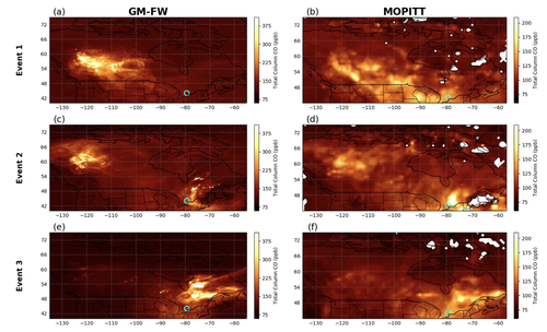
Summary: The record-breaking wildfires in 2023 consumed approximately 15 million hectares of Canadian forest. Widespread long-range transport of smoke plumes, and the trace gases associated with biomass burning, lead to pollution enhancement events across much of North America. This study examines trace gas measurements made at sites in Toronto and Egbert, Ontario during three periods (May 16‐23, June 3‐9 and June 17‐30, 2023) during which the smoke plumes were overhead. Tropospheric columns, spanning from the surface to 10 km, of seven trace gas species including CO were measured using high-resolution Fourier transform spectrometers, and correlations of these gases with CO were used to assess enhancement ratios. Notable enhancements were noted for C2H6, CH3OH, HCN, and HCOOH. Smoke plume transport was examined using the Hybrid Single‐Particle Lagrangian Integrated Trajectory model, the GEM‐MACH‐FireWork (GM‐FW) air quality model, and MOPITT CO data. Comparisons of GW-FW to MOPITT CO showed event-averaged CO columns for the model represent the plume dispersion across the country. When focused on Southern Ontario, spatial consistency is found between GW-FW and MOPITT; however, some inconsistency in the CO column is noted between the model and measurement datasets.
A Comparative Analysis of Satellite-Derived CO Retrievals During the 2020 Wildfires in North America
Marey, H. S., Drummond, J. R., Jones, D. B. A., Worden, H., Clerbaux, C., Borsdorff, T., and Gille, J.
Journal of Geophysical Research: Atmospheres https://doi.org/10.1029/2023JD039876
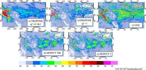
Summary: Over the past several decades, the severity, in terms of both frequency and scale, of wildfires in North America has increased due to global climate change. Particularly notable was the 2020 wildfire season, which saw the release of three times the annual emissions of CO when compared to the 2001-2019 average, with half of these emissions coming from wildfires in the western United States. In order to study the effects of the 2020 North American wildfires on atmospheric CO, retrievals from the MOPITT, Infrared Atmospheric Sounding Interferometer (IASI), and the Tropospheric Monitoring Instrument (TROPOMI) instruments were compared under both wildfire and non-wildfire conditions. Some of the results from this comparison are presented in Figure 3, which shows monthly-mean CO total columns for September 2020, with the data coming from observations collocated with those from TROPOMI.
From these comparisons, it was found that all three instruments show excellent agreement under typical atmospheric conditions (column abundances less than 3x10¹⁸ molec/cm2), but during strong enhancements notable discrepancies were observed. During these enhancements, IASI and TROPOMI consistently yielded higher CO values than MOPITT. For TROPOMI, this was identified as being the result of scattering by aerosols affecting the retrieval. For IASI, the covariance matrix used to constrain the retrievals provides only a loose constraint near the surface, allowing for increased CO in the middle troposphere during wildfire events to lead to higher surface concentrations of CO. Thus, by assessing the measurements from this diverse array of sensor under different conditions, the biases between them can be better understood, and the need for appropriate data quality filtering is emphasized.
Identifying episodic carbon monoxide emission events in the MOPITT measurement dataset
Jeffery, P. S., Drummond, J. R., Zou, J., and Walker, K. A.
Atmospheric Chemistry and Physics, 2024 https://doi.org/10.5194/acp-24-4253-2024
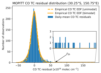
Summary: MOPITT has been measuring CO since March 2000, resulting in the longest satellite record of this trace gas to date. These CO measurements have been used in a variety of ways, including trend analyses and the construction of CO budgets; however, the influence of episodic emission events, which release large quantities of CO into the atmosphere with irregular timing, complicate their use. These episodic emission events include events such as large sporadic wildfires of natural or anthropogenic origin and are a large source of variability in CO budgets and models due to their chaotic nature. Thus, these events need to be well characterized in order to develop an improved understanding of the role they have in influencing tropospheric CO.
This study describes a multi-step algorithm that is shown to be capable of identifying large episodic emission events using the daily-mean Level 2 (L2) MOPITT total column measurements, gridded to 0.5° by 0.5° spatial resolution. The core of this algorithm involves empirically determining the expectation density function (EDF) that describes the departure of CO observations from an estimate of the baseline behaviour for this gas composed of periodic components and trends.
This algorithm is used to create a set of enhancement flag files that identify the episodic events that show strong enhancement of CO outside of the range of expected CO behaviour for the period 3 March 2000 to 31 July 2022. This study also examines the distribution and frequency of these flagged measurements, and the change in the number of flagged events between the first and latter half of this period.
A comparison of carbon monoxide retrievals between the MOPITT satellite and Canadian high-Arctic ground-based NDACC and TCCON FTIR measurements
Jalali, A., Walker, K.A., Strong, K., Buchholz, R.R., Deeter, M.N., Wunch, D., Roche, S., Wizenberg, T., Lutsch, E., McGee, E., Worden, H.M., Fogal, P., and Drummond, J.R.
Atmospheric Measurement Techniques, 2022 https://doi.org/10.5194/amt-15-6837-2022
Summary: In this paper, data from the MOPITT satellite instrument is compared against ground-based measurements of CO made in the Canadian high-Arctic, at the Polar Environment Atmospheric Research Laboratory (PEARL) in Eureka, Nunavut. This is done in order to validate the MOPITT version 8 (V8) retrievals for the purpose of ensuring the continued accuracy of MOPITT’s measurements, and in turn the scientific results derived from these. Comparison data for this work come from measurements made between 2006 and 2019 by a Bruker IFS 125HR Fourier Transform Infrared spectrometer (FTIR) located at the PEARL Ridge Laboratory. These include both mid- and near-infrared FTIR measurements made as part of the Network for the Detection for Atmospheric Composition Change (NDACC) and the Total Carbon Column Observing Network (TCCON). Only MOPITT V8 measurements made within 110 km of the PEARL Ridge Laboratory and within 24 hours of FTIR measurements are considered for this study.
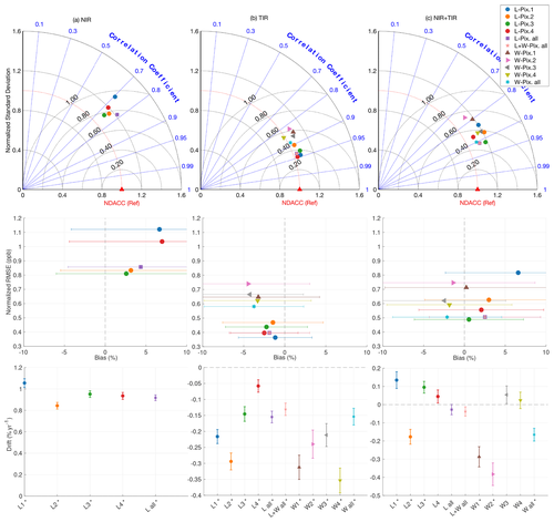
There are several MOPITT retrieval products, namely those from the near-infrared (NIR) channel, the thermal infrared (TIR) channel, and a joint (TIR–NIR) product that combines both channels. Additionally, each channel's detector has 4 pixels. To systemically evaluate the MOPITT products, pixel-to-pixel biases were determined for each pixel and product and were found to vary based on the season and whether the measurement was made over land or water. Filters were then applied to the dataset to minimize the MOPITT pixel bias and the number of outliers in the dataset.
To robustly compare the MOPITT product against the ground-based measurements, the MOPITT averaging kernels were used to weigh the NDACC and TCCON retrievals, accounting for differences in the vertical sensitivities of the satellite and FTIR measurements. The results of these comparisons are summarized in modified Taylor diagrams, which compare results from each pixel for each product over land and water against NDACC and TCCON measurements. Overall, good consistency is found between MOPITT and the NDACC and TCCON measurements, with pixel-dependant positive biases of 3 – 10 % for the NIR MOPITT retrievals, pixel-dependant negative biases of -5 – 0 % for the TIR MOPITT retrievals, and pixel-dependant biases of -4 – 7 % for the joint TIR-NIT MOPITT product. Additionally, the drift in the MOPITT biases was evaluated against the NDACC and TCCON products. The drift was found to be larger in comparisons with the NDACC products than the TCCON products for the NIR retrievals, and vice-versa in comparisons with the TIR and joint TIR-NIR retrievals. Overall, this study provided detailed validation for MOPITT V8 measurements in the Canadian high Arctic.
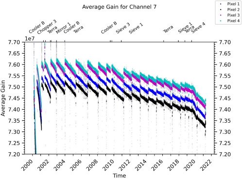
A 20-year review of the performance and operation of the MOPITT instrument
Drummond, J.R., Zanjani, Z.V., Nichitiu, F., and Zou, J.
Advances in Space Research, 2022 https://doi.org/10.1016/j.asr.2022.09.010
Summary: The MOPITT (Measurements Of Pollution In The Troposphere) instrument, aboard the Terra spacecraft, has been providing continuous measurements of carbon monoxide (CO) total columns and vertical profiles on a global scale since shortly after the launch of Terra on December 18, 1999. At the time of its launch, MOPITT was one of the first correlation radiometer instruments, utilizing a combination of Length Modulating Cells (LMCs), Pressure Modulating Cells (PMCs), and Stirling cryocoolers to observe tropospheric CO from space. At the present time, MOPITT is the only space-borne correlation radiometer instrument that measures atmospheric CO in current operation. After over 20 years of operation, an overview of the engineering telemetry of MOPITT allows for significant insight into the performance and successes of one of the longest operating satellite instruments in the space environment. This work focuses on the engineering telemetry of MOPITT’s core subsystems, with emphasis on their relation to MOPITT’s long-term successes. Particular focus is placed on how the instrument successes, including (1) achieving an extremely stable thermal and vibrational environment; (2) allowing for compensation of subsystem failures and anomalies by means of a redundant design; and (3) maintaining stable detector performance, have all contributed to MOPITT becoming the longest living operational instrument for measuring atmospheric CO columns and profiles.
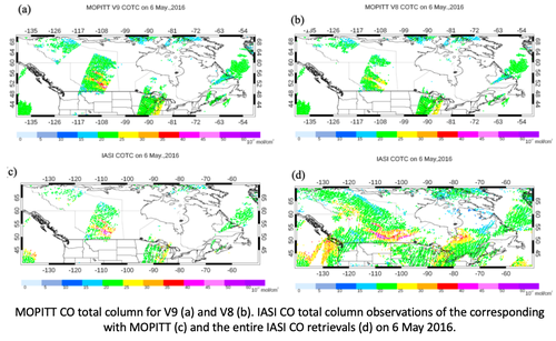
Analysis of improvements in MOPITT observational coverage over Canada
Marey, H.S., Drummond, J.R., Jones, D.B.A., Woden, H., Deeter, M.N., Gille, J., and Mao, D
Atmospheric Measurement Techniques, 15, 701–719, 2022 https://doi.org/10.5194/amt-15-701-2022
Summary: MOPITT has been measuring global tropospheric carbon monoxide (CO) since March 2000, providing the longest nearly continuous record of CO from space. Over time, the data processing algorithms have been updated to improve the quality of CO retrievals and the sensitivity to the lower troposphere. Currently, MOPITT retrievals are only performed for clear-sky observations or over low clouds for ocean scenes. The cloud detection scheme was modified in the new V9 product, resulting in an improvement in observational coverage, especially over land. Comparison of the spatial and seasonal variations of the data coverage in V9 and V8 shows differences with significant geographical and temporal variability, with some regions such as Canada and the Amazon exhibiting a doubling of data in winter. Here we conducted an analysis of Moderate Resolution Imaging Spectroradiometer (MODIS) cloud heights and cloud mask products along with MOPITT retrieval cloud flag descriptors to understand the impact of cloud conditions on the MOPITT observational coverage, with a particular focus on observations over Canada. Analyses of the standard V8 CO TC product (cloud filtered) and nonstandard product (non-cloud-masked) were conducted for selected days. Results showed some coherent structures that were observed frequently in the non-masked CO product that was not present in the V8 product and could potentially be actual CO features. The MODIS cloud height analysis revealed that a significant number of low-cloud CO retrievals were discarded in the V8 product. Most of the missed CO plumes in the V8 product are now detected in the new V9 product as a result of the dependence of the MOPITT radiance ratio (MRT) test over land. Comparisons of the MRT and MODIS cloud height data indicate a remarkable negative correlation. As a result of the modified V9 cloud detection algorithm, a significant portion of the low-cloud CO retrievals is now incorporated in the new V9 MOPITT product. Consequently, the observational coverage over Canada is significantly improved, which benefits analyses of regional CO variability, especially during extreme pollution events. We also conducted a comparison of MOPITT and IASI CO TC and found generally good agreement, with about a 5-10 % positive bias that is more pronounced in highly polluted scenes.
Regional and Urban Column CO Trends and Anomalies as Observed by MOPITT Over 16 Years
Hedelius, J. K., G. C. Toon, R. R. Buchholz, L. T. Iraci, J. R. Podolske, C. M. Roehl, P. O. Wennberg, H. M. Worden, and D. Wunch
Journal of Geophysical Research: Atmospheres, 126(5), 2021 https://doi.org/10.1029/2020JD033967.
Summary: Atmospheric carbon monoxide (CO) concentrations have decreased since the beginning of the century, and the rate of decrease depends on the region. Depending on how regions are chosen, their boundaries may not always align with where there are differences in trends. To address this, we calculate trends within 0.4° × 0.4° grid cells independently throughout the globe using satellite CO retrievals from the Measurements Of Pollution In The Troposphere (MOPITT) satellite instrument from 2002 to 2017. These trends are found with the caveat that there are large singular biomass burning events somewhere nearly every year, and we include examples of large column CO anomalies during sporadic but large burning events in the North American and Eurasian boreal forests, the Amazon, Africa, and Indonesia. CO trends behave similarly within regions that span about a few thousand kilometers. Using TransCom region definitions, we find average trends between −0.9 and 0.1 ppb year−1 (about −0.9 to 0.1% year−1) for 2002–2017. Over 5-year subsets, trends in TransCom regions vary between −3.6 and 1.8 ppb year−1. This substantial spatial and temporal variability in trends is in agreement with other studies. With an understanding of regional trends, we compare with trends from urban areas. Generally, CO trends within urban areas are indistinguishable from regional trends. This may be because of a combination of noise in the data, the large footprint for MOPITT, or because anthropogenic CO reduction measures were implemented before the MOPITT record began. We provide case studies for a few cities, such as Los Angeles, and find long-term variation in the rate of change of column CO.
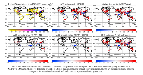
Quantifying Emissions of CO and NOx Using Observations From MOPITT, OMI, TES, and OSIRIS
Zhang, X., D. B. A. Jones, M. Keller, T. W. Walker, Z. Jiang, D. K. Henze, H. M. Worden, A. E. Bourassa, D. A. Degenstein, and Y. J. Rochon
Journal of Geophysical Research: Atmospheres, 124(2), 1170–1193, 2019 https://doi.org/10.1029/2018JD028670
Summary: The GEOS-Chem four-dimensional variational data assimilation system was used to estimate emissions of carbon monoxide (CO) and nitrogen oxides (NOx) in November 2009 and July 2010. We assimilated CO retrievals from MOPITT, ozone retrievals from the TES and OSIRIS and Nitrogen Dioxide columns from OMI. By assimilating data for multiple chemical species with the four-dimensional variational scheme we obtain a consistent chemical state over the assimilation period. The modeled ozone bias was reduced to less than 3.5 ppbv everywhere, relative to independent aircraft ozone data, except in the high-latitude upper troposphere and lower stratosphere. We found that in November, the CO and NOx emission estimates obtained with the multiple species assimilation were generally comparable to those inferred from assimilating only MOPITT or OMI data, respectively, whereas in July the differences were larger. For the main anthropogenic source regions, the inferred North American and European emissions responded most strongly to the multispecies information in the assimilation. In July, North American and European CO emission estimates differed by 31% and 65% relative to the MOPITT-only estimates, respectively. We also found large differences for the North American and European NOx emission estimates, which differed by 27% and 16% relative to the OMI-only estimates, respectively. Our results highlight the potential benefit of exploiting the additional constraints offered by multispecies chemical data assimilation.
Large horizontal gradients in atmospheric CO at the synoptic scale as seen by spaceborne Measurements of Pollution in the Troposphere
Liu, J., J. R. Drummond, D. B. A. Jones, Z. Cao, H. Bremer, J. Kar, J. Zou, F. Nichitiu, and J. C. Gille
Journal of Geophysical Research: Atmospheres, 111(D2), 2006 https://doi.org/10.1029/2005JD006076
Summary: In the MOPITT data, large horizontal gradients in CO, coherent at the synoptic scale, have been observed. The concentration of CO varies rapidly by as much as 50–100% across distances of ∼100 km, forming distinct boundaries in the CO distribution. These can last one to several days and span horizontal distances of 600–1000 km. On average, such events were observed in the MOPITT CO daily images once every 3–4 days over North America in spring and summer 2000. It was found that the large horizontal gradients typically reflect the differential vertical and horizontal transport of air with different chemical signatures. The results demonstrate that MOPITT can capture the influence of synoptic processes on the horizontal and vertical distribution of CO. The large gradients in CO observed on synoptic scales represent valuable information that can be exploited to improve our understanding of atmospheric CO. In particular, these results suggest that the MOPITT observations provide a useful data set with which to address a range of issues from air quality on local/regional scales to long‐range transport of pollution on continental/global scales.
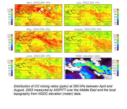
Carbon monoxide (CO) maximum over the Zagros mountains in the Middle East: Signature of mountain venting?
Kar, J., J. R. Drummond, D. B. A. Jones, J. Liu, F. Nichitiu, J. Zou, J. C. Gille, D. P. Edwards, and M. N. Deeter
Geophysical Research Letters, 33(15), L15819, 2006 https://doi.org/10.1029/2006GL026231
Summary: Enhanced CO is observed over the Zagros mountains of Iran, following the local topography over this region (25–40N, 40–60E). The MOPITT averaging kernels do not seem to indicate any data artifacts in this area. We argue that this feature likely forms by the process of mountain venting by thermal winds caused by strong daytime differential heating. This is consistent with an analysis of vertical velocity in the NCEP reanalysis data in this region. The phenomenon was observed in all the years of available MOPITT measurements and may have implications for the pollution episodes in the region and the Middle East ozone maximum that has been observed earlier.
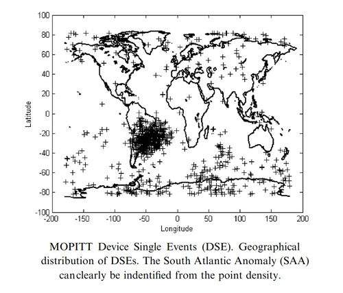
Solar particle events seen by the MOPITT instrument
Florian Nichitiu, James R. Drummond , Jiansheng Zou , Robert Deschambault
Journal of Atmospheric and Solar-Terrestrial Physics, 66(18), pp 1797-1803, 2004 https://doi.org/10.1016/j.jastp.2004.06.002
Summary: This paper reports on Device Single Events (DSEs) occurring in the Measurements Of Pollution In The Troposphere (MOPITT) space instrument piezoelectric accelerometers. It is found that DSEs correlate with the radiation environment, solar activity and high intensity Solar Proton Events.
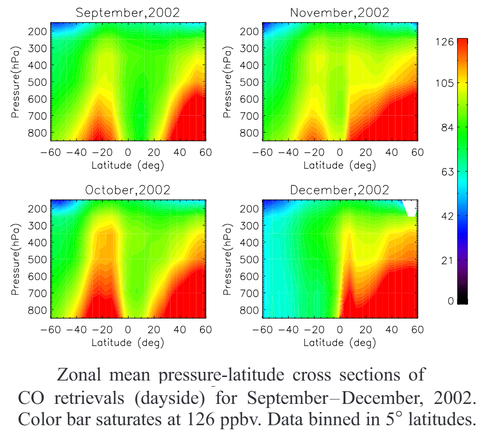
Evidence of vertical transport of carbon monoxide from Measurements of Pollution in the Troposphere (MOPITT)
Jayanta Kar, Holger Bremer, James R. Drummond, Yves J. Rochon, Dylan B. A. Jones, Florian Nichitiu, Jason Zou, Jane Liu, John C. Gille, David P. Edwards, Merritt N. Deeter, Gene Francis, Dan Ziskin, and Juying Warner
Geophysical Research Letters, 31, L23105 https://doi.org/10.1029/2004GL021128
Summary: Vertical profiles of carbon monoxide (CO) mixing ratio retrieved from MOPITT measurements have been analyzed. It was find that variations in the vertical structure of CO can be detected in the MOPITT data. The Asian summer monsoon plume in CO is observed for the first time as a strong enhancement of CO in the upper troposphere (UT) over India and southern China indicating the effect of deep convective transport. Similarly, zonal mean height latitude cross‐sections for the months of September–December, 2002 indicate deep convective transport of CO from biomass burning in the southern tropics. These findings show that MOPITT CO can provide valuable information on vertical transport phenomena in the troposphere.